August 28, 2007
Global Positioning
Since I don't have a car in Taiwan I didn't really have any need for the fancy PDA+GPS combos with the fancy screen and full route-finding functionality. I was intrigued by the concept of geotagging photos with location data, though. I tried adding location data to my Flickr photos by hand via TripperMap in conjunction with Google Earth. But that's not practical to do for all my photos, and even just doing the Flickr uploads was becoming tedious.
A quick search found that a basic bluetooth/USB capable GPS receiver had fallen well below $100, well into impulse-purchase territory. Had to go to Germany on short notice, so I picked up a little GPS receiver unit with built-in trail-recording function just in time for the trip.
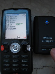
The setup consisted of Mobile Trail Explorer running on my SE W810i phone, connected via bluetooth to the Wintec WBT-201 G-Rays2 GPS receiver. The WBT-201 has built-in memory to record track data, but the Java program on the phone has a nicer interface. Took the picture of the GPS readout to synchronize the clocks between the GPS and the camera.
Directly download the tracks from the phone via Bluetooth file transfer, or grab it from the WBT using HoudahGPS. Put the GPS data into the photos with GPS Photo Linker.
Thankfully the new iPhoto 7.0 in iLife '08 finally fixed GPS data handling so editing the photo won't screw up the coordinates in the edited file. And Flickr can directly read the EXIF geotags to place them on the map, which can be exported as a GeoRSS or KML feed to be read in Google Maps or Google Earth.
Posted by mikewang on 08:40 AM